PR-TF 58 Camino del Risco
Technical information:
- Start:
-
Uphill: Trailhead at the checkpoint on Punta de Teno road, Carretera TF-445 KM 2.5
-
Uphill: Trailhead at Teno Alto Square - Buenavista del Norte
-
- Finish:
-
Downhill: Trailhead at Teno Alto Square - Buenavista del Norte
-
Downhill: Trailhead at the checkpoint on Punta de Teno road, Carretera TF-445 KM 2.5
-
- Trail administration status: Officially administered and maintained as PR TF 58 in Teno Rural Park
- Degree of difficulty: Intermediate
- Type of route: Out and back (with the option of a loop if connecting with other trails)
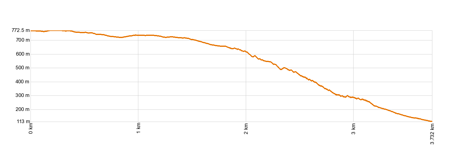
- Distance: 3.46 km
- Duration: 2h 45 min
- Highest point: 770 m
- Lowest point: 130 m
- Cumulative elevation gain: 650 m
- Cumulative elevation loss: 650 m
- Connections to other trails:
- At the end of the uphill climb, PR TF 51 toward San José de Los Llanos - 18 km
- PR TF 51 toward Punta de Teno - 4 km with the option of the loop connecting with the Risco Path Trail and the Carretera Punta de Teno (NOTE: a light source is recommended for the Teno tunnel, in addition to reflective material)
- PR TF 57 toward El Palmar - 3.9 km
- Teno Self-Guided Loop Trail - 2.8 km
- At the end of the uphill climb, PR TF 51 toward San José de Los Llanos - 18 km
- Protected Nature Areas:
- Authorisation required: For individuals, no type of authorisation is required. For companies, we advise contacting the office of the Teno Rural Park. Before undertaking this activity, we recommend checking the weather forecast and possible alerts for adverse weather conditions in the area.
- Competent authority: Tenerife Council
- About the competent authority: PR-TF 58 Camino del Risco
Trail description
The El Risco footpath is an old trail with natural steps leading down to Buenavista. It begins at Plaza de Los Bailaderos in Teno Alto (in the municipality of Buenavista del Norte). Heading north along the track of La Mulata, you will come to Las Barreras de Puerto Malo. There, cross the track by Casas de La Torre, go past the track of Gollada and continue ahead towards El Alto del Risco and La Erita, an aboriginal meeting place, where the descent begins. Walk along the western side of the ravine of Aderno to the point where it meets the ravine of Bujamé, which is where the footpath ends, in Casablanca, roughly 2 km (1.2 miles) away from the town centre.
Hypsometry
For your own safety, don't forget to check the condition of the trail.
The competent authority will be responsible for informing you if the trail is not recommendable in the wake of adverse weather conditions, as well as if the trail or part of it is closed, etc.
In case of an emergency, call 112.